Many US state, river and city names came into English from the languages of the Native nations who lived there first, and still do. Michigan comes from an Ojibwe word for a big lake, Mississippi from the Ojibwe for great river, Chicago from the Miami-Illinois word for a wild onion, and Massachusetts from the Massachusett people, named for a great hill. For some names, like Minnesota, Ohio and Utah, people who study names do not agree on the meaning, and the table says so. The map in this pack is made up: its lakes, rivers and portage trails (where a canoe is carried over land between waters) are our own invention, with English names that mean the same as some of the real ones. The meanings come from state, university and library sources.
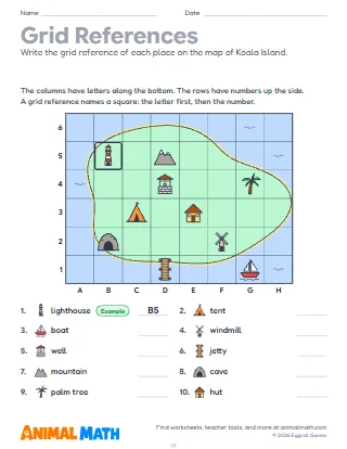
Four pages use the same made-up map of Lake Country. Page 1 asks what is in a square and which square a place is in. Page 2 asks for compass directions between places and has two "go 2 squares north" moves. Page 3 measures routes by counting squares and using the scale, 1 square = 2 miles. Page 4 compares two canoe routes to Rice Lake: one with more paddling, one with more carrying. Page 5 has a table of real place names, the nation or language each comes from and its meaning, and matches them to the map. The first question on pages 1, 2 and 5 is a worked example.
Before page 1, practice "letter first, then number" on the map together. On page 4, ask why travelers might choose a route with less carrying even when it is the same length. After page 5, look for Native place names in your own state.
Look at a map of your state together and find rivers, lakes or towns whose names come from a Native language. Look up which nation's language each comes from.
This pack supports the following Common Core State Standards for Mathematics:
© Copyright 2010. National Governors Association Center for Best Practices and Council of Chief State School Officers. All rights reserved.
Map reading on a made-up lake country of canoe routes and portages, with a table of real US place names that come from Native languages. Students find grid squares, name compass directions, measure routes with a scale and match the map's places to names like Michigan and Mississippi.
Tell us what to make next, or build your own with a worksheet maker.
This worksheet is free to download, print, copy, and hand out in your classroom or at home. You do not need to create an account, and there are no watermarks on the PDF.